Product Design, Manufacturing & Innovation Resources
Home » Online Tools » ECMWF Weather Forecasts (10 days, medium-range)

ECMWF Weather Forecasts (10 days, medium-range)

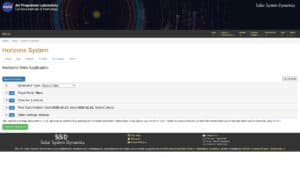
If you are looking for a 10-days weather tendency, il all formats, this is it: the European Centre for Medium-Range Weather Forecasts (ECMWF) provides a global operational service for numerical weather prediction and climate data analysis. It utilizes the Integrated Forecasting System (IFS) to generate high-resolution atmospheric, marine, and land-surface forecasts, ranging from medium-range to seasonal timescales.

The platform offers a diverse array of products, including:

  • Ensemble forecasts that quantify atmospheric uncertainty and probability.
  • The ERA5 reanalysis dataset, providing a comprehensive historical climate record.
  • Real-time data streams for atmospheric composition and ocean wave modeling.

These outputs are distributed via graphical charts and specialized datasets, serving as a primary resource for meteorological research and commercial forecasting.

Professionals in engineering and science apply ECMWF’s high-fidelity datasets to optimize renewable energy yields and design infrastructure resilient to extreme environmental stressors.

In manufacturing and supply chain management, these predictive insights are integrated into decision-support systems to mitigate risks associated with weather-related logistics disruptions and raw material shortages.

Innovation teams in the environmental and insurance sectors further utilize the center’s historical reanalysis data to develop predictive risk models and validate climate-adaptation technologies.

Disciplines: Meteorology, Climate science, Aviation, Energy, Agriculture, Maritime.
Free alternative to Windy, NOAA GFS, Meteoblue.
ECMWF Weather Forecasts compared with Windy, NOAA GFS and Meteoblue
ECMWF Weather ForecastsWindyNOAA GFSMeteoblue
Models and forecast range: ECMWF open data covers IFS HRES, IFS ENS and the AIFS models. The IFS medium-range runs reach 360 hours (15 days) for the 00 and 12 UTC runs, and only 144 hours for the 06 and 18 UTC runs. Ensemble products include probabilities and tropical cyclone tracks.Models and forecast range: Windy is a visualization platform that names ECMWF, GFS and NEMS as its forecast models. It adds radar, satellite and more than 50 weather layers.Models and forecast range: GFS provides analysis and forecasts out to 16 days. Base grid spacing is about 28 km, dropping to about 70 km for forecasts one to two weeks ahead. It runs four cycles per day.Models and forecast range: The free API lists a Trend package with a 14-day ensemble. Other packages include Basic, Agro, Wind, Clouds, Solar, Air and Air Quality.
Resolution and formats: Open data is provided at 0.25 degrees in GRIB2, with tropical cyclone tracks in BUFR. Higher-resolution versions need a Real-time Dissemination Service Agreement.Resolution and formats: NODD offers 0.25 and 0.5 degree products, and NCEI offers 0.5 and 1 degree. Forecast output is every 3 hours in the NODD products. Access is by HTTPS and THREDDS.Resolution and formats: The free API has a maximum time resolution of 1 hour. Most other packages are at 3 hours, 6 hours or daily.
Intended use: ECMWF serves meteorological research and commercial forecasting. Its datasets also include the ERA5 reanalysis for historical climate records.Intended use: The audience named by Windy includes kiters, surfers, paragliders, pilots and sailors. Aviation reports (METAR, TAF, NOTAM) and SYNOP station and buoy observations are shown.Intended use: The API packages target agriculture, wind and solar energy, and air quality, among others.
Access and licence: Open data is released under CC-BY-4.0 with the ECMWF Terms of Use, so commercial use and redistribution are allowed with attribution. Only the most recent 12 runs are retained, about 2 to 3 days. Copies are available on AWS, Azure and Google Cloud.Access and licence: The Point Forecast API excludes ECMWF entirely because of licensing conditions. The free Testing tier is limited to 500 requests per day, returns randomly modified data and is for development only. The Professional tier is paid.Access and licence: NODD holds recent high-resolution data in a trailing 30-day window on AWS, and NCEI holds long-term lower-resolution data.Access and licence: A free API key is valid for one year and includes 10 million credits. Sea, Multimodel, Seasonal and Nowcast packages are not part of it. Paid tiers add all variables and resolution down to 5 minutes for most packages.

More GIS, Resources tools

Suggest your best online tool:

Do you know a better, a complementary or a replacement website to the one listed above ?

> Suggest it here <

10th year anniversary

Full size images and downloads are only available, 100% free, for registered members.

> Login <