Product Design, Manufacturing & Innovation Resources
Home » Online Tools » Radiaverse Radiation Map

Radiaverse Radiation Map

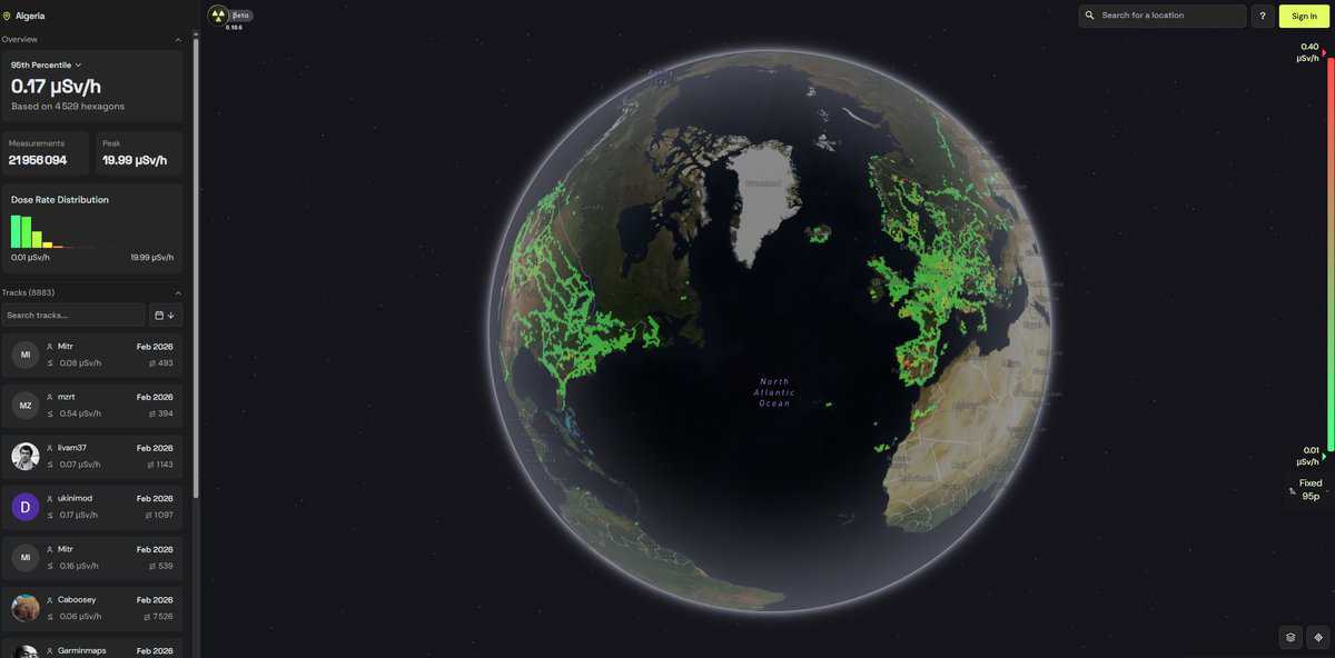
An interactive worldwide radioactivity / radiations map made by customers of the “RadiaCode” connected products recording their local area/path automatically tagging the GPS coordinates.

Not fully scientific calibrated instruments, but interesting as a curiosity before investigating more.

Note their disclaimer advise:

Emergency and Reporting

Disciplines: Radiation protection, Environmental monitoring, Nuclear engineering, Public health.
Free alternative to Safecast.
Radiaverse Radiation Map compared with Safecast
Radiaverse Radiation MapSafecast
Data source: Tracks recorded automatically with GPS tags by owners of Radiacode connected detectors. Radiacode 100 series devices use a CsI(Tl) scintillator in the 102, 103 and 110 models and a GAGG(Ce) scintillator in the 103G.Data source: Volunteer measurements, mainly ambient dose rate, collected with the bGeigie Nano, a GPS-enabled mobile sensor used for car-borne mapping and static readings, and with the newer bGeigie Zen.
Calibration and validity: The map is described as not fully calibrated scientific data. It is a screening aid and a curiosity, not a basis for dose assessment. Radiacode devices cover 0.01 to 1000 microsievert per hour (0.01 to 400 for the 110).Calibration and validity: Large volunteer dataset built after the 2011 Fukushima accident. A 2020 study used more than 120 million observations to estimate mean ambient dose rates in 330 cities. Instrument specifications are not given on the data page.
Spectral information: The source detectors are gamma spectrometers, so the energy spectrum can be examined on the device, for example for K-40, Th-232, Ra-226, Cs-137 or U-238. Whether the map itself exposes spectra was not confirmed.Spectral information: The data page describes dose-rate measurements. Spectral data is not mentioned.
Access and licence: The dataset is released under CC0, available as a full CSV file, through an API at api.safecast.org and in the AWS Registry of Open Data. The website itself is under CC BY-NC 4.0.
When to choose it: Choose it to look at recent readings from consumer spectrometer owners near a place of interest, then verify with a proper instrument.When to choose it: Choose it when you need an open, reusable dataset, a long time series or a documented collection method for research or citation.

Topics covered: Radiation, Radioactivity, GPS coordinates, RadiaCode, Interactive map, Dose rate, Emergency services, Competent authority, NORM, Incident response, Source recovery, Calibration, ISO 11929, IEC 61010, ASTM E2623, and IAEA Safety Standards..

More GIS, Live Monitoring & Tracking tools

Suggest your best online tool:

Do you know a better, a complementary or a replacement website to the one listed above ?

> Suggest it here <

10th year anniversary

Full size images and downloads are only available, 100% free, for registered members.

> Login <