… or when bureaucracy or regulation takes over common sense in the airport?

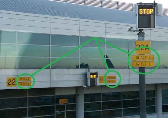
These latitude/longitude coordinates plates, all the same, are all printed repeatedly, 3 to 5 meters away from each other. In one blink of an eye, this is what you see:
One may think that indicating more frequently is more convenient than less because you see one plate faster, no?
… well … that is very arguable: it can be confusing (“Why different plates? Are they all the same? Should I read all to decide? …”)
Really helpful, just bureaucracy or regulation?
As a reminder (the only technical part in this blog)
XX° xx,xy‘ one unit variation of y = 2nd decimal place of minutes = 1.1km !!!
… so likely all the airport building has exactly the same plates over and over (lower printing cost because of volumes? ;)
So in fact, precision is just enough to tell to the pilot “look at your map, you are indeed this this airport”.
Could a real pro pilot confirm or explain in the comments below?


Just curious, but arent these strange GPS coordinates just standard aviation regulation? Or is this something more?
These GPS plates, bureaucracy or not, sure they arent hiding some secret government UFO landing sites? Just saying…
Interesting topic! But are these GPS plates truly helpful or just another layer of unnecessary airport red tape? Lets discuss!
Related Posts
Latest Publications & Patents on Metal-Organic Frameworks (MOFs)
Latest Publications & Patents on Covalent Organic Frameworks (COFs)
Latest Publications & Patents on Aerogels and Aerographene
Latest Publications & Patents on High-Entropy Oxides (HEOs)
Latest Publications & Patents on MXenes
Latest Publications & Patents on Quantum Dots