Product Design, Manufacturing & Innovation Resources
Heim » Online-Tools » Jetstream Nordamerika 10-Tage-Vorhersagekarte

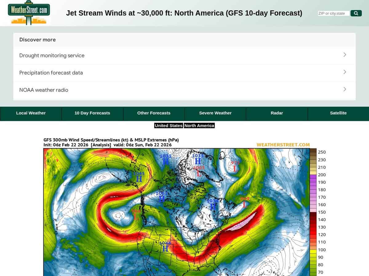
Jetstream Nordamerika 10-Tage-Vorhersagekarte

Aktuelle Lage und 10-Tage-Vorhersage der Jetstream-Position und -Intensität mit Windgeschwindigkeiten in Knoten. Die WeatherStreet GFS Jetstream-Windvorhersage liefert meteorologische Daten aus großer Höhe und visualisiert Windgeschwindigkeit und -richtung in 250 hPa Höhe. Druck Das Wettergeschehen erstreckt sich über ganz Nordamerika. Mithilfe des numerischen Modells des Global Forecast System (GFS) generiert der Dienst eine Reihe synoptischer Karten, die die polaren und subtropischen Jetstreams über einen mehrtägigen Vorhersagehorizont verfolgen.

Es umfasst Nordamerika und einen Teil Südamerikas. Für detailliertere Informationen kann der Fokus auf die USA beschränkt werden.

Nützlich für Aktivitäten in großer Höhe oder für astronomische Langzeit-Zeitrafferaufnahmen. Aerospace engineers and flight operations specialists utilize these forecasts to optimize transcontinental flight paths, leveraging tailwinds to reduce fuel consumption and identifying potential clear-air turbulence zones to ensure structural integrity. In the fields of science and innovation, the data is applied to:

  • Vorhersage der Zugbahn und Intensivierung von Zyklonen in mittleren Breiten, die Produktionslieferketten und Logistik stören.
  • Modellierung der kinetischen Energie in großen Höhen zur Innovation bei luftgestützten Windenergieanlagen (AWE).
  • Analyse atmosphärischer Blockierungsmuster zur Vorhersage extremer Temperaturereignisse, die sich auf die industrielle Kühlung und die Belastung der Energienetze auswirken.
Disziplinen: Luftfahrt, Meteorologie, Segeln.
Kostenlose Alternative zu Windy: SkyVector.
Jetstream North America 10d Forecast Map compared with Windy and SkyVector
Jetstream Nordamerika 10-Tage-VorhersagekarteWindigSkyVector
Forecast source: The page is built on the GFS numerical model and shows a 10 day forecast of jet stream winds. The map is labelled with a 300 mb pressure level, given as about 30,000 ft.Forecast source: Windy lists ECMWF, GFS and NEMS as forecast models on its site. The user can therefore switch between models, which a single GFS chart does not allow.
Scope of the service: It is a single purpose chart of high altitude wind for one region, with no other weather layers on the page.Scope of the service: Windy is an animated worldwide weather map with 50+ layers, weather radar and satellite imagery, plus spot forecasts.Scope of the service: SkyVector provides aeronautical charts, online mapping and an enhanced flight planning suite, with weather and data overlays. It was founded in 2006.
Geografische Abdeckung: The maps cover North America, with a link to a US only map for more local detail.Geografische Abdeckung: The map covers the whole world.Geografische Abdeckung: Its aeronautical charts are described as worldwide.
Aviation data: It gives only upper level wind speed and direction, which is the input for en route wind and turbulence assessment.Aviation data: Windy shows METAR, TAF and NOTAMs for any airport, and SYNOP codes from stations and buoys.Aviation data: SkyVector adds airport information and FBO listings to its charts.

Behandelte Themen: Jetstream, Nordamerika, 10-Tage-Vorhersage, Windgeschwindigkeiten, Knoten, meteorologische Daten, Windgeschwindigkeit, Richtung, 250-mb-Druckniveau, Globales Vorhersagesystem, synoptische Karten, polarer Jetstream, subtropischer Jetstream, transkontinentale Flugrouten, Klarluftturbulenzen, außertropische Zyklonen, Luftwindenergie ISO 9001, ISO 14001, ISO 50001, ASHRAE 901 und ASTM D5721.

Mehr GIS, Live-Überwachung und -Verfolgung Werkzeuge

Empfehlen Sie Ihr bestes Online-Tool:

Kennen Sie eine bessere, ergänzende oder alternative Website zu der oben genannten?

> Hier vorschlagen <

10. Jahr Jubiläum

Bilder in voller Größe und Downloads sind nur für registrierte Mitglieder 100% kostenlos verfügbar.

> Login <