Product Design, Manufacturing & Innovation Resources
家 » オンラインツール » ジェット気流北米10日間予報図

ジェット気流北米10日間予報図

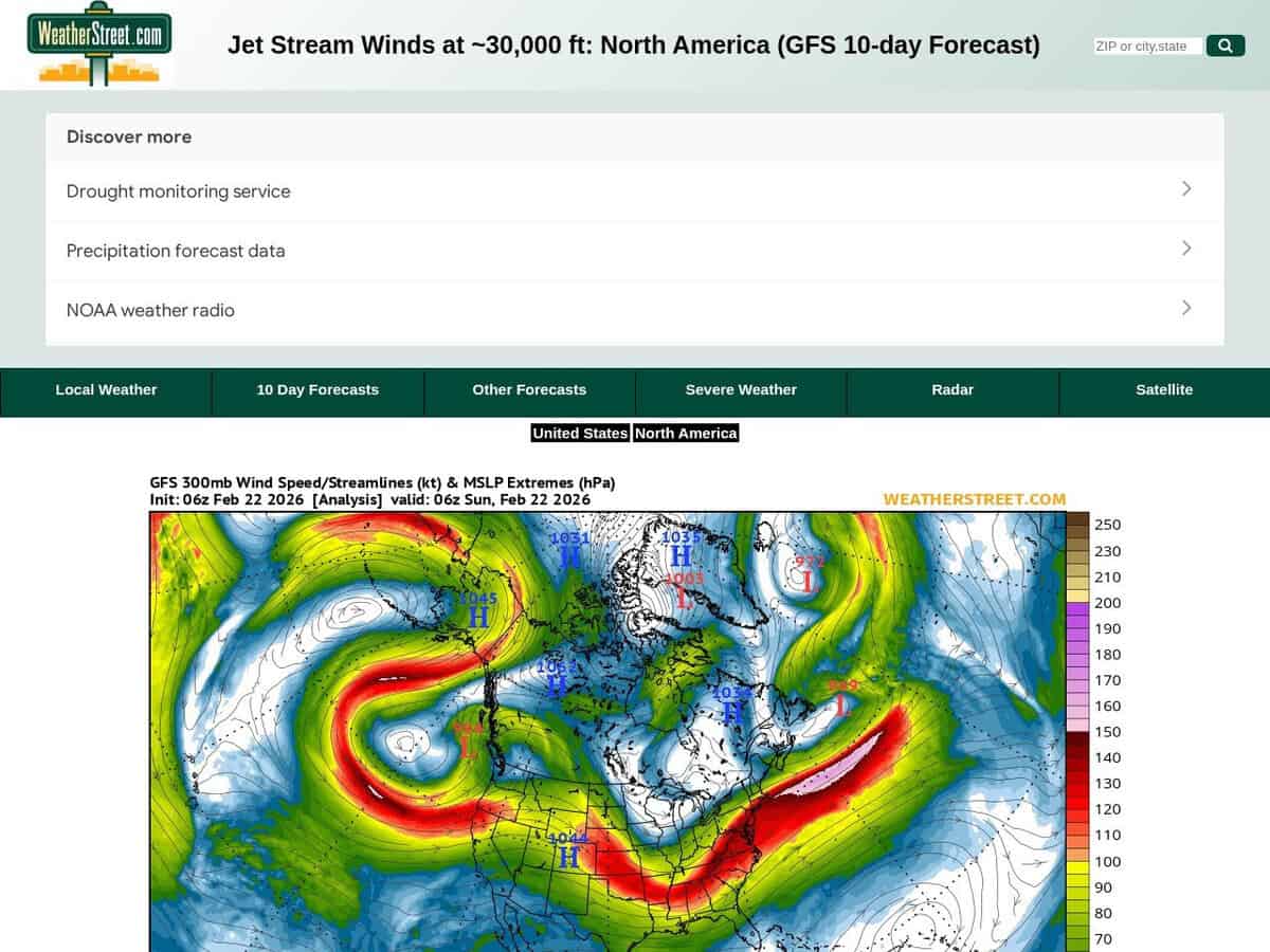
ジェット気流の位置と強さ、および風速(ノット)の現状と10日間の予報。 WeatherStreetのGFSジェットストリーム風予報は、250mb高度における風速と風向を視覚化した高高度気象データを提供します。 プレッシャー 北米全域にわたるレベル。このサービスは、全球予報システム(GFS)数値モデルを利用して、数日間の予報期間にわたって極ジェット気流と亜熱帯ジェット気流を追跡する一連の天気図を作成します。

対象地域は北米と南米の一部です。より詳細な地域情報が必要な場合は、米国のみに絞り込むことも可能です。

高地での活動や、長時間にわたる天体写真撮影に役立ちます。 Aerospace engineers and flight operations specialists utilize these forecasts to optimize transcontinental flight paths, leveraging tailwinds to reduce fuel consumption and identifying potential clear-air turbulence zones to ensure structural integrity. In the fields of science and innovation, the data is applied to:

  • 製造業のサプライチェーンや物流を混乱させる中緯度低気圧の進路と勢力の増大を予測する。
  • 空中風力発電(AWE)システムの革新に向けた、高高度における運動エネルギーのモデリング。
  • 大気ブロッキングパターンを分析し、産業用冷却や電力網負荷に影響を与える極端な気温現象を予測する。
分野: 航空、気象学、セーリング。
Windyの無料代替ソフト、SkyVector。
Jetstream North America 10d Forecast Map compared with Windy and SkyVector
ジェット気流北米10日間予報図風が強いSkyVector
Forecast source: The page is built on the GFS numerical model and shows a 10 day forecast of jet stream winds. The map is labelled with a 300 mb pressure level, given as about 30,000 ft.Forecast source: Windy lists ECMWF, GFS and NEMS as forecast models on its site. The user can therefore switch between models, which a single GFS chart does not allow.
Scope of the service: It is a single purpose chart of high altitude wind for one region, with no other weather layers on the page.Scope of the service: Windy is an animated worldwide weather map with 50+ layers, weather radar and satellite imagery, plus spot forecasts.Scope of the service: SkyVector provides aeronautical charts, online mapping and an enhanced flight planning suite, with weather and data overlays. It was founded in 2006.
地理的範囲: The maps cover North America, with a link to a US only map for more local detail.地理的範囲: The map covers the whole world.地理的範囲: Its aeronautical charts are described as worldwide.
Aviation data: It gives only upper level wind speed and direction, which is the input for en route wind and turbulence assessment.Aviation data: Windy shows METAR, TAF and NOTAMs for any airport, and SYNOP codes from stations and buoys.Aviation data: SkyVector adds airport information and FBO listings to its charts.

取り上げるトピック: ジェット気流、北米、10 日間予報、風速、ノット、気象データ、風速、風向、250 mb 気圧レベル、全球予報システム、天気図、極ジェット気流、亜熱帯ジェット気流、大陸横断飛行経路、晴天乱気流、中緯度低気圧、空中風力エネルギー、ISO 9001、ISO 14001、ISO 50001、ASHRAE 901、および ASTM D5721。

もっと GIS, リアルタイム監視と追跡 tools

おすすめのオンラインツールを教えてください。

上記のウェブサイトよりも優れた、補完的な、あるいは代替となるウェブサイトをご存知ですか?

> こちらから提案してください <

10年目 周年

フルサイズの画像とダウンロードは、登録会員のみが100%無料で利用できます。