Product Design, Manufacturing & Innovation Resources
집 » 온라인 도구 » 제트기류 북미 10일 예보 지도

제트기류 북미 10일 예보 지도

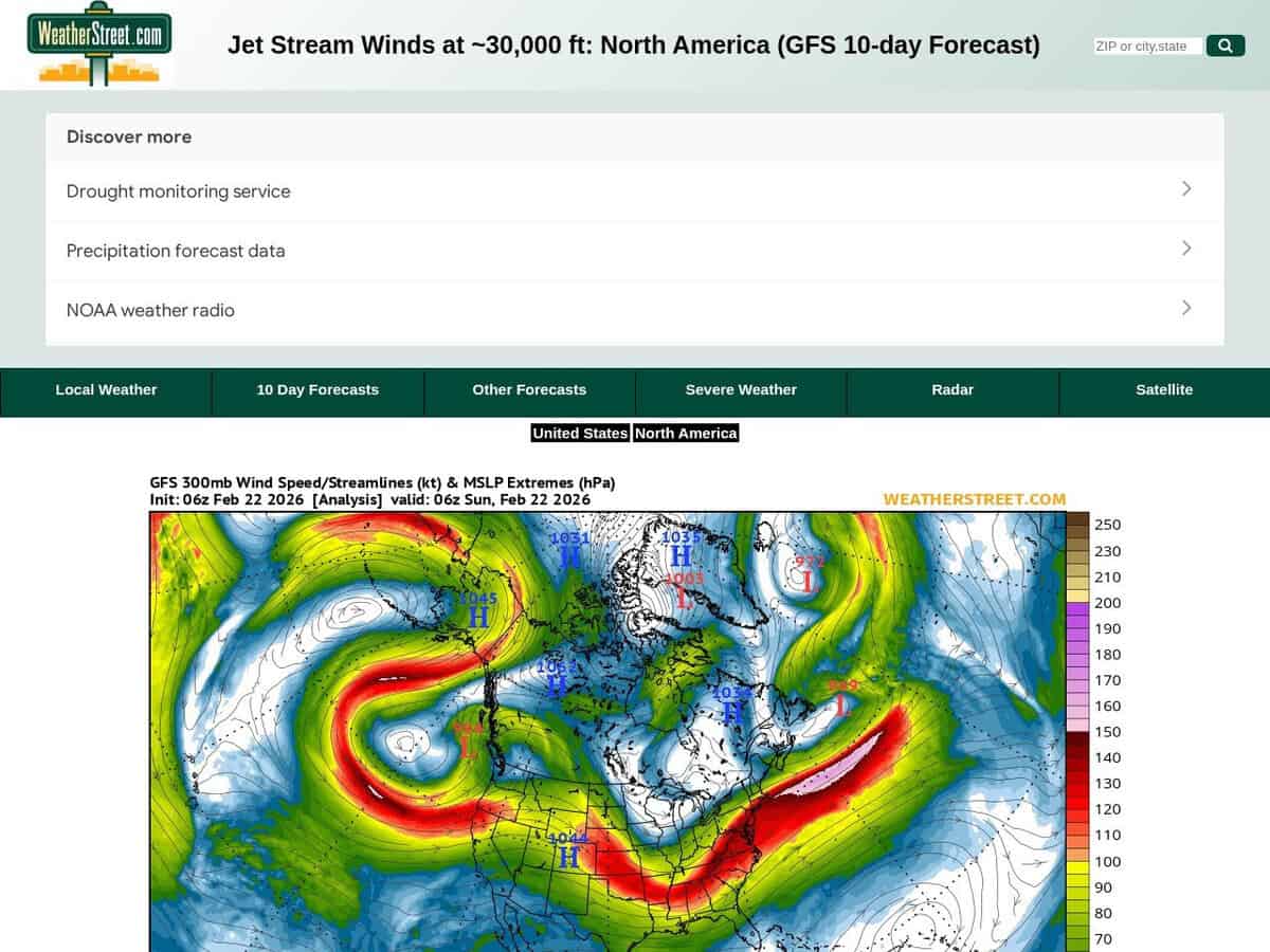
제트기류의 위치와 강도에 대한 현재 상황 및 향후 10일간의 예보(풍속은 노트 단위)입니다. WeatherStreet GFS 제트기류 풍향 예보는 250mb 고도에서의 풍속과 풍향을 시각화한 고고도 기상 데이터를 제공합니다. 압력 북미 전역에 걸쳐 안정적인 기상 조건을 제공합니다. 이 서비스는 지구예보시스템(GFS) 수치 모델을 활용하여 여러 날에 걸친 예보 기간 동안 극지방 및 아열대 제트기류의 움직임을 추적하는 일련의 기상도를 생성합니다.

북미와 남미 일부 지역을 포함합니다. 더 자세한 지역 정보를 원하시면 미국에만 초점을 맞출 수 있습니다.

고고도 활동이나 장시간 타임랩스 천체 사진 촬영에 유용합니다. Aerospace engineers and flight operations specialists utilize these forecasts to optimize transcontinental flight paths, leveraging tailwinds to reduce fuel consumption and identifying potential clear-air turbulence zones to ensure structural integrity. In the fields of science and innovation, the data is applied to:

  • 제조업 공급망과 물류를 교란하는 중위도 저기압의 이동 경로 및 강도 예측.
  • 공중 풍력 에너지(AWE) 시스템 혁신을 위한 고고도 운동 에너지 모델링.
  • 대기 차단 패턴을 분석하여 산업 냉각 및 에너지망 부하에 영향을 미치는 극한 온도 현상을 예측합니다.
분야: 항공학, 기상학, 항해학.
Windy의 무료 대안인 SkyVector입니다.
Jetstream North America 10d Forecast Map compared with Windy and SkyVector
제트기류 북미 10일 예보 지도깜짝 놀란SkyVector
Forecast source: The page is built on the GFS numerical model and shows a 10 day forecast of jet stream winds. The map is labelled with a 300 mb pressure level, given as about 30,000 ft.Forecast source: Windy lists ECMWF, GFS and NEMS as forecast models on its site. The user can therefore switch between models, which a single GFS chart does not allow.
Scope of the service: It is a single purpose chart of high altitude wind for one region, with no other weather layers on the page.Scope of the service: Windy is an animated worldwide weather map with 50+ layers, weather radar and satellite imagery, plus spot forecasts.Scope of the service: SkyVector provides aeronautical charts, online mapping and an enhanced flight planning suite, with weather and data overlays. It was founded in 2006.
지리적 범위: The maps cover North America, with a link to a US only map for more local detail.지리적 범위: The map covers the whole world.지리적 범위: Its aeronautical charts are described as worldwide.
Aviation data: It gives only upper level wind speed and direction, which is the input for en route wind and turbulence assessment.Aviation data: Windy shows METAR, TAF and NOTAMs for any airport, and SYNOP codes from stations and buoys.Aviation data: SkyVector adds airport information and FBO listings to its charts.

다룬 주제: 제트기류, 북미, 10일 예보, 풍속, 노트, 기상 데이터, 풍속, 풍향, 250mb 기압, 지구예보시스템, 일기도, 극제트기류, 아열대제트기류, 대륙횡단 비행 경로, 청천난류, 중위도 저기압, 공중 풍력 에너지, ISO 9001, ISO 14001, ISO 50001, ASHRAE 901 및 ASTM D5721.

더 GIS, 실시간 모니터링 및 추적 도구

가장 유용한 온라인 도구를 추천해 주세요:

위에 소개된 웹사이트보다 더 나은, 보완적인 또는 대체할 만한 웹사이트를 알고 계신가요?

> 여기에 제안해 주세요 <

10년차 기념일

고화질 이미지 및 다운로드는 등록된 회원에게만 100% 무료로 제공됩니다.

> 로그인 <