Product Design, Manufacturing & Innovation Resources
घर » ऑनलाइन उपकरण » जेटस्ट्रीम उत्तरी अमेरिका 10 दिवसीय पूर्वानुमान मानचित्र

जेटस्ट्रीम उत्तरी अमेरिका 10 दिवसीय पूर्वानुमान मानचित्र

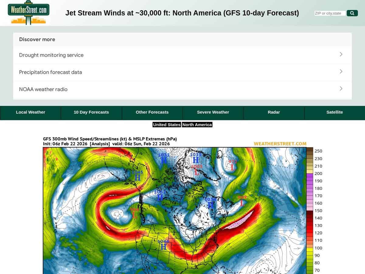
जेटस्ट्रीम की स्थिति और तीव्रता का वर्तमान पूर्वानुमान और अगले 10 दिनों का पूर्वानुमान, जिसमें हवा की गति नॉट में दी गई है। वेदरस्ट्रीट जीएफएस जेटस्ट्रीम पवन पूर्वानुमान 250 एमबी पर हवा की गति और दिशा को दर्शाने वाला उच्च-ऊंचाई वाला मौसम संबंधी डेटा प्रदान करता है। दबाव यह सेवा उत्तरी अमेरिका में समान स्तर पर चलती है। ग्लोबल फोरकास्ट सिस्टम (जीएफएस) के संख्यात्मक मॉडल का उपयोग करते हुए, यह सेवा कई दिनों के पूर्वानुमान कालक्रम में ध्रुवीय और उपोष्णकटिबंधीय जेट स्ट्रीम को ट्रैक करने वाले सिनॉप्टिक चार्ट की एक श्रृंखला तैयार करती है।

इसमें उत्तरी अमेरिका और दक्षिण अमेरिका का कुछ हिस्सा शामिल है। अधिक स्थानीय जानकारी के लिए इसे केवल अमेरिका पर केंद्रित किया जा सकता है।

ऊंचाई वाले क्षेत्रों में की जाने वाली गतिविधियों या लंबे समय तक चलने वाली खगोलीय फोटोग्राफी के लिए उपयोगी। Aerospace engineers and flight operations specialists utilize these forecasts to optimize transcontinental flight paths, leveraging tailwinds to reduce fuel consumption and identifying potential clear-air turbulence zones to ensure structural integrity. In the fields of science and innovation, the data is applied to:

  • विनिर्माण आपूर्ति श्रृंखलाओं और रसद को बाधित करने वाले मध्य अक्षांशीय चक्रवातों के प्रक्षेप पथ और तीव्रता का पूर्वानुमान लगाना।
  • वायुजनित पवन ऊर्जा (AWE) प्रणालियों में नवाचार के लिए उच्च ऊंचाई वाली गतिज ऊर्जा का मॉडलिंग करना।
  • औद्योगिक शीतलन और ऊर्जा ग्रिड भार को प्रभावित करने वाली चरम तापमान घटनाओं का पूर्वानुमान लगाने के लिए वायुमंडलीय अवरोधन पैटर्न का विश्लेषण करना।
विषय: विमानन, मौसम विज्ञान, नौकायन।
Windy का निःशुल्क विकल्प, SkyVector।
Jetstream North America 10d Forecast Map compared with Windy and SkyVector
जेटस्ट्रीम उत्तरी अमेरिका 10 दिवसीय पूर्वानुमान मानचित्रतूफ़ानीSkyVector
Forecast source: The page is built on the GFS numerical model and shows a 10 day forecast of jet stream winds. The map is labelled with a 300 mb pressure level, given as about 30,000 ft.Forecast source: Windy lists ECMWF, GFS and NEMS as forecast models on its site. The user can therefore switch between models, which a single GFS chart does not allow.
Scope of the service: It is a single purpose chart of high altitude wind for one region, with no other weather layers on the page.Scope of the service: Windy is an animated worldwide weather map with 50+ layers, weather radar and satellite imagery, plus spot forecasts.Scope of the service: SkyVector provides aeronautical charts, online mapping and an enhanced flight planning suite, with weather and data overlays. It was founded in 2006.
भौगोलिक कवरेज: The maps cover North America, with a link to a US only map for more local detail.भौगोलिक कवरेज: The map covers the whole world.भौगोलिक कवरेज: Its aeronautical charts are described as worldwide.
Aviation data: It gives only upper level wind speed and direction, which is the input for en route wind and turbulence assessment.Aviation data: Windy shows METAR, TAF and NOTAMs for any airport, and SYNOP codes from stations and buoys.Aviation data: SkyVector adds airport information and FBO listings to its charts.

शामिल विषय: जेटस्ट्रीम, उत्तरी अमेरिका, 10-दिवसीय पूर्वानुमान, हवा की गति (नॉट्स में), मौसम संबंधी डेटा, हवा का वेग, दिशा, 250 एमबी दबाव स्तर, वैश्विक पूर्वानुमान प्रणाली, सिनॉप्टिक चार्ट, ध्रुवीय जेटस्ट्रीम, उपोष्णकटिबंधीय जेटस्ट्रीम, अंतरमहाद्वीपीय उड़ान पथ, स्वच्छ वायु अशांति, मध्य अक्षांश चक्रवात, वायुजनित पवन ऊर्जा, आईएसओ 9001, आईएसओ 14001, आईएसओ 50001, ASHRAE 901 और ASTM D5721।

अधिक गिस, लाइव मॉनिटरिंग और ट्रैकिंग tools

अपना सर्वश्रेष्ठ ऑनलाइन टूल सुझाएं:

क्या आप ऊपर दी गई वेबसाइट से बेहतर, पूरक या प्रतिस्थापन वेबसाइट जानते हैं?

> यहां सुझाव दें <

नवीनतम परिवर्धन

शीर्ष पोस्ट और लेख

शीर्ष मूल उपकरण

10वां वर्ष सालगिरह

पंजीकृत सदस्यों के लिए पूर्ण आकार की छवियाँ और डाउनलोड 100% निःशुल्क उपलब्ध हैं।