Product Design, Manufacturing & Innovation Resources
Heim » Online-Tools » Erdsatellitenansichten (EU Copernicus Sentinel-Konstellationen)

Erdsatellitenansichten (EU Copernicus Sentinel-Konstellationen)

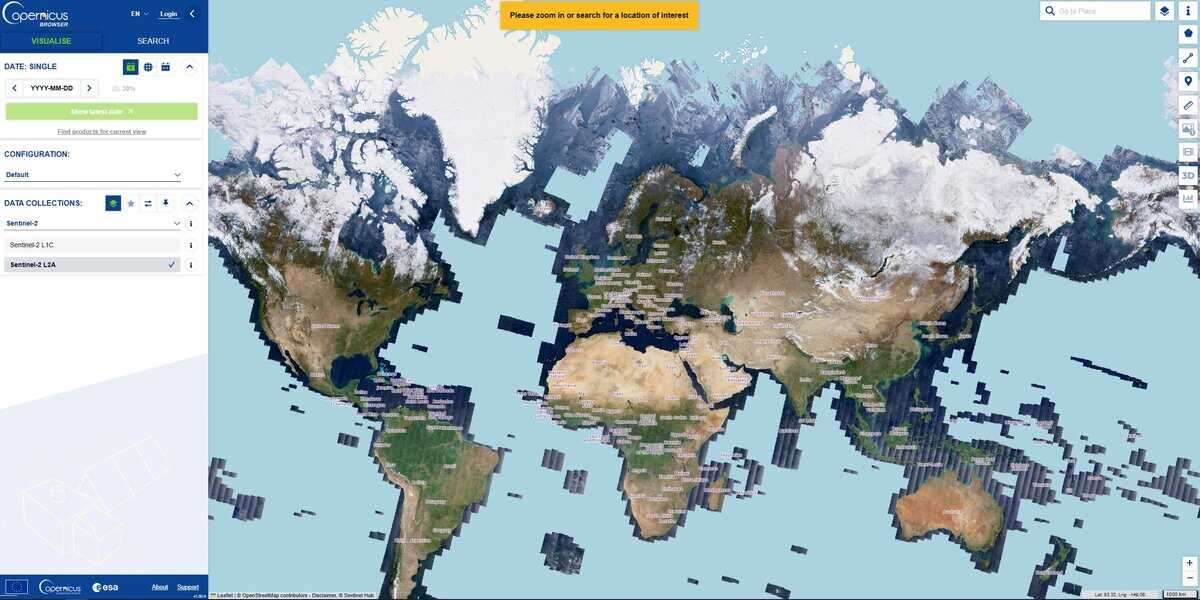
Die Website bietet Satellitenbilder von nahezu der gesamten Erde, kontinuierlich und ortsbezogen zu vielen Zeitpunkten, sodass sich jede Entwicklung leicht verfolgen lässt.

Die Copernicus-Sentinel-Konstellationen sind eine Flotte von Erdbeobachtungssatelliten, die von der Europäischen Weltraumorganisation (ESA) und der Europäischen Union entwickelt und betrieben werden. Sie bilden die Weltraumkomponente von Copernicus, dem weltweit ambitioniertesten zivilen Erdbeobachtungsprogramm, das freie und offene Daten zur Verfügung stellt, um die Umwelt zu überwachen und zu verstehen. Klimawandelund die zivile Sicherheit zu gewährleisten.

Der Begriff „Konstellation“ wird verwendet, da die meisten Sentinel-Missionen aus zwei identischen Satelliten bestehen, die in derselben Umlaufbahn, aber um 180° versetzt, fliegen. Diese Anordnung gewährleistet, dass jeder Teil der Erde häufig abgetastet wird (hohe „Überflugzeit“), was wichtig ist, um schnelllebige Ereignisse wie Überschwemmungen oder Pflanzenwachstum zu verfolgen.

Die hier verfügbaren Daten stammen von Sentinel-2 (Optical Imaging), das hochauflösende Farbbilder (multispektral) der Erdoberfläche aufnimmt, die sich hervorragend für die Landwirtschaft (Überwachung der Pflanzengesundheit), die Forstwirtschaft, die Landnutzungskartierung und die Bewältigung von Naturkatastrophen wie Waldbränden eignen.

Die Auflösung mag nicht die beeindruckendste sein, wenn es darum geht, kleinste Details zu finden, aber sie ergänzt andere Werkzeuge hervorragend und ist eine starke Forschungsressource, um ein großes Gebiet über einen längeren Zeitraum zu analysieren.

Je nach Region und Datum stehen möglicherweise mehrere Ebenen zur Verfügung, von den Echtfarben bis hin zu SWIR, NDVI, NDWI und anderen, die zusammen mit dem Wolkenfilter für optimale Ergebnisse verwendet werden können.

Disziplinen: Fernerkundung, Umweltwissenschaften, Landwirtschaft, Klimaforschung, Katastrophenmanagement, Forstwirtschaft.
Kostenlose Alternative zu Google Earth Engine, Planet Explorer und USGS EarthExplorer.
Earth Satellite Views (EU Copernicus Sentinel constellations) compared with Google Earth Engine, Planet Explorer and USGS EarthExplorer
Erdsatellitenansichten (EU Copernicus Sentinel-Konstellationen)Google Earth EnginePlanet ExplorerUSGS EarthExplorer
Data and resolution: Copernicus Browser offers Sentinel-1, Sentinel-2 (L1C and L2A), Sentinel-3, Sentinel-5P and two DEMs. Sentinel-2 has 13 bands, four at 10 m, six at 20 m and three at 60 m, with a combined revisit of 5 days for the 2A and 2B pair.Data and resolution: A cloud platform for analysis of large public geospatial catalogues and your own data. Resolution depends on the dataset chosen.Data and resolution: PlanetScope at about 3 m with near daily coverage, and SkySat at about 1 m. Finer resolution than Sentinel-2, but from a commercial source.Data and resolution: Datasets include Landsat, MODIS, radar, DEMs, LiDAR, aerial and commercial imagery, and Sentinel-2 is also available.
Analysetools: Custom band composites, indices such as NDVI (bands B4 and B8) and NDWI, custom JavaScript visualization scripts, a cloud filter (30 percent by default) and time-lapse export to GIF or MP4. Services can be exposed as WMS, WMTS, WFS or WCS.Analysetools: Programmatic processing over the whole catalogue, billed in compute hours for commercial use. This suits large-scale time series, but it needs scripting skills.Analysetools: Search, filter and preview of scenes in the browser, with download and API access for subscribers.Analysetools: Search and download of scenes, with footprints in CSV, shapefile or KMZ. Processing is done offline in your own software. Level 1 GeoTIFF is the usual analysis product.
Kosten und Zugang: Free, with a free account required for the browser. No commercial licence is needed.Kosten und Zugang: Noncommercial and research use is free. Commercial plans are offered as Basic and Professional subscriptions, plus usage fees per compute hour.Kosten und Zugang: Paid plans. Daily monitoring is sold on contract.Kosten und Zugang: Downloads are free with a free USGS account.
Learning curve: Low for viewing and index maps, moderate for custom scripts. A good starting point for agronomists, foresters and environmental scientists.Learning curve: High, because analysis is written as code.Learning curve: Low for browsing, moderate for API work.Learning curve: Moderate: you must choose products and processing levels, then handle files yourself.
Wann man es wählen sollte: Choose it for free, repeatable monitoring of large areas over time, such as crop health, burn scars, flooding or land use, when 10 m detail is sufficient.Wann man es wählen sollte: Choose it when you must process years of imagery across large regions.Wann man es wählen sollte: Choose it when metre-scale detail and frequent revisits justify a commercial budget.Wann man es wählen sollte: Choose it when you need Landsat archives or other US federal data products.

Behandelte Themen: Erdbeobachtung, Copernicus, Sentinel-Satelliten, Multispektrale Bildgebung, Hohe Wiederholungsrate, Umweltüberwachung, Klimawandel, Landwirtschaftliche Überwachung, Landnutzungskartierung, Katastrophenmanagement, Optische Bildgebung, Fernerkundung, SWIR, NDVI, NDWI, Wolkenfilterung, Datenzugänglichkeit, Freie und offene Daten ISO 19115, ISO 19130, ISO 19157, ISO 19139 und ISO 19126.

Mehr 2D-Grafiken, GIS, OSINT Werkzeuge

Empfehlen Sie Ihr bestes Online-Tool:

Kennen Sie eine bessere, ergänzende oder alternative Website zu der oben genannten?

> Hier vorschlagen <

10. Jahr Jubiläum

Bilder in voller Größe und Downloads sind nur für registrierte Mitglieder 100% kostenlos verfügbar.

> Login <