Product Design, Manufacturing & Innovation Resources
घर » ऑनलाइन उपकरण » पृथ्वी के उपग्रह दृश्य (ईयू कोपरनिकस सेंटिनल तारामंडल)

पृथ्वी के उपग्रह दृश्य (ईयू कोपरनिकस सेंटिनल तारामंडल)

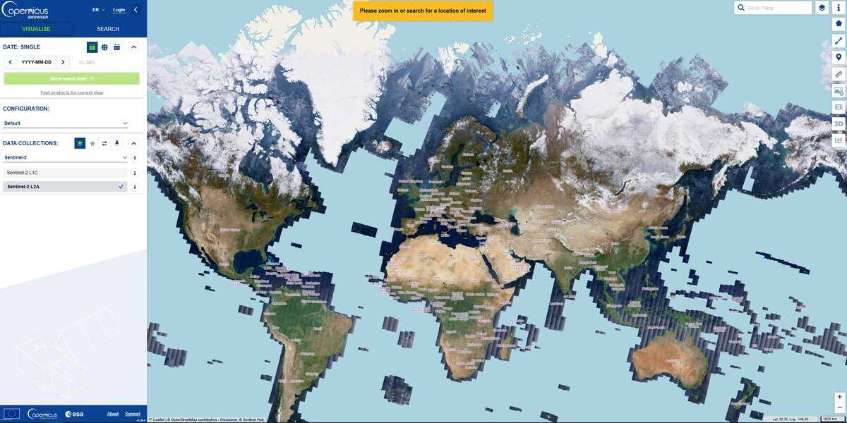
यह साइट लगभग पूरी पृथ्वी के उपग्रह दृश्य निरंतर रूप से प्रदान करती है, जिसे कई तिथियों पर स्थान के आधार पर देखा जा सकता है, जिससे किसी भी विकास को आसानी से ट्रैक किया जा सकता है।

कोपरनिकस सेंटिनल उपग्रह समूह यूरोपीय अंतरिक्ष एजेंसी (ईएसए) और यूरोपीय संघ द्वारा डिजाइन और संचालित पृथ्वी अवलोकन उपग्रहों का एक बेड़ा है। ये कोपरनिकस के "अंतरिक्ष घटक" हैं, जो दुनिया का सबसे महत्वाकांक्षी नागरिक पृथ्वी अवलोकन कार्यक्रम है, जो पर्यावरण की निगरानी और समझ विकसित करने में मदद करने के लिए मुफ्त और खुला डेटा प्रदान करता है। जलवायु परिवर्तनऔर नागरिक सुरक्षा सुनिश्चित करें।

'कॉन्स्टेलेशन' शब्द का प्रयोग इसलिए किया जाता है क्योंकि अधिकांश सेंटिनल मिशन में दो एक जैसे उपग्रह एक ही कक्षा में 180 डिग्री के कोण पर गति करते हैं। यह व्यवस्था सुनिश्चित करती है कि पृथ्वी के प्रत्येक भाग को बार-बार स्कैन किया जाए (उच्च 'रीविजिट टाइम'), जो बाढ़ या फसल वृद्धि जैसी तीव्र गति वाली घटनाओं पर नज़र रखने के लिए महत्वपूर्ण है।

यहां उपलब्ध डेटा सेंटिनल-2 (ऑप्टिकल इमेजिंग) से लिया गया है, जो पृथ्वी की सतह की उच्च-रिज़ॉल्यूशन वाली रंगीन छवियां (मल्टीस्पेक्ट्रल) कैप्चर करता है, जो कृषि (फसल स्वास्थ्य की निगरानी), वानिकी, भूमि उपयोग मानचित्रण और जंगल की आग जैसी प्राकृतिक आपदाओं के प्रबंधन के लिए बहुत उपयोगी है।

यदि लक्ष्य सबसे छोटे विवरणों को खोजना है तो रिज़ॉल्यूशन शायद सबसे प्रभावशाली न हो, लेकिन यह अन्य उपकरणों के लिए बहुत ही पूरक है और समय के साथ एक बड़े क्षेत्र का विश्लेषण करने के लिए एक मजबूत शोध संसाधन है।

क्षेत्र और तारीख के आधार पर, सर्वोत्तम परिणामों के लिए क्लाउड फ़िल्टर के साथ उपयोग किए जाने वाले कई लेयर्स उपलब्ध हो सकते हैं, जिनमें वास्तविक रंग, SWIR, NDVI, NDWI और अन्य शामिल हैं।

विषय: रिमोट सेंसिंग, पर्यावरण विज्ञान, कृषि, जलवायु अनुसंधान, आपदा प्रबंधन, वानिकी।
गूगल अर्थ इंजन, प्लैनेट एक्सप्लोरर और यूएसजीएस अर्थ एक्सप्लोरर का निःशुल्क विकल्प।
Earth Satellite Views (EU Copernicus Sentinel constellations) compared with Google Earth Engine, Planet Explorer and USGS EarthExplorer
पृथ्वी के उपग्रह दृश्य (ईयू कोपरनिकस सेंटिनल तारामंडल)Google Earth Engineग्रह अन्वेषकUSGS EarthExplorer
Data and resolution: Copernicus Browser offers Sentinel-1, Sentinel-2 (L1C and L2A), Sentinel-3, Sentinel-5P and two DEMs. Sentinel-2 has 13 bands, four at 10 m, six at 20 m and three at 60 m, with a combined revisit of 5 days for the 2A and 2B pair.Data and resolution: A cloud platform for analysis of large public geospatial catalogues and your own data. Resolution depends on the dataset chosen.Data and resolution: PlanetScope at about 3 m with near daily coverage, and SkySat at about 1 m. Finer resolution than Sentinel-2, but from a commercial source.Data and resolution: Datasets include Landsat, MODIS, radar, DEMs, LiDAR, aerial and commercial imagery, and Sentinel-2 is also available.
विश्लेषण उपकरण: Custom band composites, indices such as NDVI (bands B4 and B8) and NDWI, custom JavaScript visualization scripts, a cloud filter (30 percent by default) and time-lapse export to GIF or MP4. Services can be exposed as WMS, WMTS, WFS or WCS.विश्लेषण उपकरण: Programmatic processing over the whole catalogue, billed in compute hours for commercial use. This suits large-scale time series, but it needs scripting skills.विश्लेषण उपकरण: Search, filter and preview of scenes in the browser, with download and API access for subscribers.विश्लेषण उपकरण: Search and download of scenes, with footprints in CSV, shapefile or KMZ. Processing is done offline in your own software. Level 1 GeoTIFF is the usual analysis product.
लागत और पहुंच: Free, with a free account required for the browser. No commercial licence is needed.लागत और पहुंच: Noncommercial and research use is free. Commercial plans are offered as Basic and Professional subscriptions, plus usage fees per compute hour.लागत और पहुंच: Paid plans. Daily monitoring is sold on contract.लागत और पहुंच: Downloads are free with a free USGS account.
Learning curve: Low for viewing and index maps, moderate for custom scripts. A good starting point for agronomists, foresters and environmental scientists.Learning curve: High, because analysis is written as code.Learning curve: Low for browsing, moderate for API work.Learning curve: Moderate: you must choose products and processing levels, then handle files yourself.
इसे कब चुनें: Choose it for free, repeatable monitoring of large areas over time, such as crop health, burn scars, flooding or land use, when 10 m detail is sufficient.इसे कब चुनें: Choose it when you must process years of imagery across large regions.इसे कब चुनें: Choose it when metre-scale detail and frequent revisits justify a commercial budget.इसे कब चुनें: Choose it when you need Landsat archives or other US federal data products.

शामिल विषय: पृथ्वी अवलोकन, कोपरनिकस, सेंटिनल उपग्रह, बहु-स्पेक्ट्रल इमेजिंग, उच्च पुनरीक्षण समय, पर्यावरण निगरानी, ​​जलवायु परिवर्तन, कृषि निगरानी, ​​भूमि उपयोग मानचित्रण, प्राकृतिक आपदा प्रबंधन, ऑप्टिकल इमेजिंग, रिमोट सेंसिंग, एसडब्ल्यूआईआर, एनडीवीआई, एनडीडब्ल्यूआई, क्लाउड फ़िल्टरिंग, डेटा अभिगम्यता, निःशुल्क और खुला डेटा, आईएसओ 19115, आईएसओ 19130, आईएसओ 19157, आईएसओ 19139 और आईएसओ 19126।

अधिक 2D ग्राफ़िक्स, गिस, ओएसइंट tools

अपना सर्वश्रेष्ठ ऑनलाइन टूल सुझाएं:

क्या आप ऊपर दी गई वेबसाइट से बेहतर, पूरक या प्रतिस्थापन वेबसाइट जानते हैं?

> यहां सुझाव दें <

नवीनतम परिवर्धन

शीर्ष पोस्ट और लेख

शीर्ष मूल उपकरण

10वां वर्ष सालगिरह

पंजीकृत सदस्यों के लिए पूर्ण आकार की छवियाँ और डाउनलोड 100% निःशुल्क उपलब्ध हैं।