Product Design, Manufacturing & Innovation Resources
Home » CentipedeRTK free Live GNSS Bases Map

CentipedeRTK free Live GNSS Bases Map

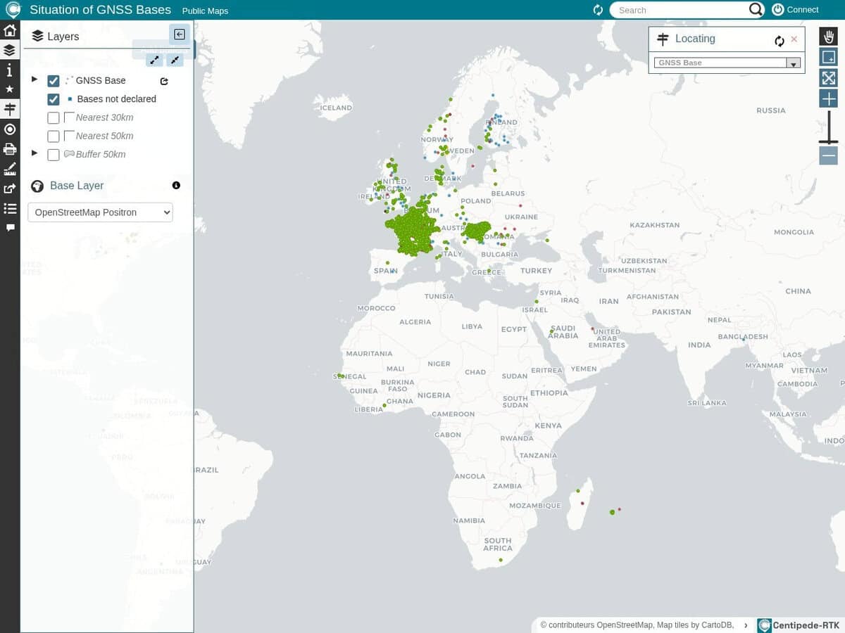
CentipedeRTK is a collaborative network of open GNSS bases available to anyone within the coverage area. The network is extended by public institutions, individuals, private actors such as farmers, and other public partners.

Initially a French initiative, now well implemented also in Hungary and Switzerland, plus a few bases in Europe and North America.

If you need GPS/GNSS centimeter accuracy for your application, you need a fixed base, perfectly positioned and receiving the GNSS signal also. Either you have your own base, or you use this open source group of bases and the real time corrective signal of its closest base.

Alternatives networks of bases exist … commercial. A must for your rover, mobility or agricultural project.

Note that you can also collaborate and share the real time GNSS correction of your location. The opensource RTKBase system & app is available for your Raspberry to stream your live data online for the CentipedeRTK visitors.

Topics covered: CentipedeRTK, GNSS, open source, collaborative network, real-time correction, centimeter accuracy, fixed base, positioning, public institutions, agricultural project, RTKBase system, Raspberry Pi, live data streaming, coverage area, Europe, North America, and GNSS signal..

Suggest your best sites:

Do you know a better, a complementary or a replacement website to the one listed above ?

> Suggest it here <

All Tools Categories:

  • 2D Graphics (40)
    All about computer 2D graphics, colors and art
  • AI (11)
    Best online tools and ressources to increase your productivity, innovation and creativity with AI and Machine Learning
  • CAD, 3D Graphics (8)
    All about computer CAD and 3D Graphics software.
  • Calculation (19)
  • Coding (16)
  • Communication (14)
    All communication tools that are not internet related (look at the dedicated > Network & web < category for these). These include the various 2G to 5G tools or analogical and numerical radio protocols.
  • Fun (5)
    Less useful tools, but with a technical, engineering or graphical principle. Or just original and curiosity.
  • GIS (14)
    Geographic Information System (GIS) tools for gathering, managing, and analyzing data that uses spatial location. These tools integrate earth and space maps, tools, remote sensing data and spatial analytics.
  • innovation.world (13)
    Our own original Engineering and product design tools, that we had to build as no similar was existing (or at least we could not find the same)
  • Language (4)
  • Network & Web (62)
  • OSINT (21)
    Open Source Intelligence (OSINT) online tools, with at least a freemium mode, that focus more specifically on OSINT than tools listed in the "Resource" or "Search" section
  • Patents & Brands (10)
  • Projects (8)
    All aspects and stages of R&D projects development, from ideation, research, presentation to project management
  • Resources (44)
    Libraries, databases, repositories, classifieds
  • Search (44)
    Search engines and search tools, from the most famous ones to very specialized. Note that standards and regulations search have their dedicated "Standards" category and therefore not included here.
  • Simulation (14)
  • Standards (7)
    Standards, norms and regulations from all over the world for engineering, product design and safety
  • Text Related (18)
    All related to text, such as writing, translating, correcting services

Full size images and downloads are only available, 100% free, for registered members.

> Login <