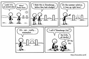
Bandes dessinées : Des publications anciennes révèlent un suivi précoce du solstice
Notre vision optimiste de l'actualité du jour : des chercheurs ont mis au jour un monument rudimentaire composé de deux piliers alignés avec le soleil.
Notre vision optimiste de l'actualité du jour : des chercheurs ont mis au jour un monument rudimentaire composé de deux piliers alignés avec le soleil.
This week: decarbonisation, life-cycle assessment, urban microclimate, resilience optimization, contrail formation, atmospheric radiative forcing, flight trajectory optimization, weather parameters, volumetric

This week: UAV, flight termination, control network, electronic speed controllers, biopesticides, natural oils, precision agriculture, regulatory compliance, microwave radiometer, flicker

This week: health therapies, light arrays, hydrogen inhalation, oxygen bubbler, model compression, deep neural networks, batch normalization, loss function, motorized
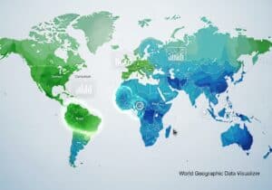
Cet outil gratuit de carte mondiale choroplèthe innovation.world permet de visualiser et de comparer n'importe quelle donnée pays par pays directement dans votre navigateur. Avec

This week: Lidar, 3D object detection, autonomous vehicle, point cloud data, LiDAR, aquatic environment, diode lasers, time-of-flight, robot path planning,

This week: Hypernetworks, content recontextualization, Low-Rank Adaptation, generative model, version control, natural language processing, artificial intelligence, content tracking, few-shot learning,
This week: Geolocation, Caching, Access Point, Network Identifiers, threat assessment, artificial intelligence, generative AI, domain-specific data, Natural Language Processing, Summarization,