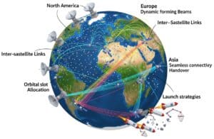
Les constellations d'internet par satellite déploient un grand nombre de satellites en orbite basse pour fournir une connectivité haut débit mondiale à faible latence. Les liaisons inter-satellites et les antennes à réseau phasé permettent la formation de faisceaux dynamique et une réutilisation efficace du spectre. La topologie du réseau et l'attribution des créneaux orbitaux influent sur la couverture et la capacité, tandis que les mécanismes de transfert assurent une connectivité continue lors des déplacements des satellites. Les réseaux de stations au sol assurent l'interface avec les segments spatiaux, prenant en charge le routage des données et la gestion de la constellation. Les stratégies de lancement et la réduction des débris spatiaux doivent garantir la durabilité opérationnelle (qui n'est pas encore atteinte).
Voici notre dernière sélection de publications et de brevets mondiaux en anglais sur les constellations Internet par satellite, parmi de nombreuses revues scientifiques en ligne, classées et axées sur la constellation Internet par satellite, le satellite en orbite basse, la liaison intersatellite, l'antenne réseau à commande de phase, la formation de faisceaux par satellite, le déploiement de constellations, la topologie du réseau satellitaire, l'attribution de créneaux orbitaux, la réutilisation des fréquences, le transfert par satellite, le réseau de stations au sol, la conception de charges utiles par satellite, architecture du segment spatial, liaison transversale de satellite, gestion de constellation, mise à l'échelle de constellation de satellite, réduction des débris orbitaux, communication par satellite, allocation dynamique de bande passante, gestion de puissance de satellite, systèmes de suivi de satellite, simulation de constellation, couverture de constellation, redondance de constellation, synchronisation de constellation, routage de constellation, sécurité de constellation, maintenance de constellation, constellation internet et constellation de satellites.
Communication method and apparatus
Patent published on the 2026-07-02 in WO under Ref WO2026138375 by YINWANG INTELLIGENT TECH CO LTD [CN] (Zhu Hualin [cn], Sun Wei [cn])
Abstract: A communication method and apparatus, which can be applied to the technical field of vehicles. The method comprises: a first communication apparatus acquiring service-required information of a target service, and sending first information to a second communication apparatus, the first information comprising the service-required information, and being used for triggering the second communication apparatus to request the target service from a third communication apparatus, wherein data is transmit[...]
Our summary: The communication method involves a first apparatus acquiring service information and sending it to a second apparatus. The second apparatus uses satellite communication to request the target service from a third apparatus. This method allows service requests without reliance on cellular networks, ensuring functionality in low or no signal conditions.
communication method, satellite communication, vehicle technology, service request
Patent
Link-layer address concealment for transmission security (transec) enabled terminals in satellite communication networks
Patent published on the 2026-06-25 in US under Ref US20260181386 by HUGHES NETWORK SYSTEMS LLC [US] (Border John [us])
Abstract: [0000] Approaches are described herein for link-layer address concealment for transmission security (TRANSEC) enabled (TE) terminals in satellite communication networks. For example, TE terminals can randomly select a proposed masked system assigned identifier (mSAI), which is a temporary identifier different from any real identifiers of the terminal (e.g., a real SAI, real electronic serial number, etc.). The ground station (e.g., inroute group manager) checks availability of the mSAI. If avail[...]
Our summary: This content discusses methods for link-layer address concealment in TRANSEC-enabled terminals within satellite communication networks. TE terminals utilize a masked system assigned identifier (mSAI) to enhance security by masking real identifiers. The ground station manages mSAI requests, ensuring availability and bandwidth allocation for secure data transmission.
link-layer address concealment, transmission security, satellite communication networks, masked system assigned identifier
Patent
Systems and methods for transmission path compensation for satellite communications
Patent published on the 2026-06-18 in WO under Ref WO2026127975 by RAVE AEROSPACE LLC [US] (Berioli Matteo [de], Luecke Oliver [us], Makhloga Nitin Singh [us], Rasheed Tinku [de])
Abstract: Broadband satellite terminals are described that comprise an upconverter and power amplifier that are not collocated. The terminals are configured to automatically calculate an upconverter gain value to account for signal losses and/or gains between the first modem and the power amplifier in local oscillator, frequency, and modulation.[...]
Our summary: The document describes systems for transmission path compensation in satellite communications. It details broadband satellite terminals with an upconverter and power amplifier that are not collocated. These terminals automatically calculate an upconverter gain value to address signal losses and gains.
transmission path compensation, satellite communications, upconverter gain, broadband satellite terminals
Patent
Battery pack and wireless communication apparatus and wireless communication method thereof
Patent published on the 2026-05-27 in EP under Ref EP4749882 by SAMSUNG SDI CO LTD [KR] (Kim Min Su [kr])
Abstract: The present disclosure relates to a battery pack and a wireless communication apparatus, and a wireless communication method thereof. The battery pack comprises a pack case; a plurality of battery modules mounted inside the pack case; a plurality of slave battery management systems (BMSs) that are mounted on each battery module and collect battery status information of each battery module; and a master BMS configured to receive the battery status information from each of the plurality of slave B[...]
Our summary: The disclosure presents a battery pack with multiple battery modules and slave BMSs. Each slave BMS collects status information and communicates with a master BMS via RF. The communication utilizes a repeater and an active phased array antenna system for integration and management.
Battery pack, wireless communication, battery management system, phased array antenna
Patent
Space-based internet hosting
Patent published on the 2026-05-21 in US under Ref US20260143408 by HUGHES NETWORK SYSTEMS LLC [US] (Roy Satyajit [us], Choquette George [us])
Abstract: Methods, systems, and apparatus, including computer programs encoded on computer storage media, for applying intelligent routing techniques. In some implementations, a system obtains, from a satellite communication network, trajectory information for a device configured to communicate with an Internet host located in space. The system determines a first path for communication between the device and the Internet host located in space, wherein the first path includes one or more links. The system [...]
Our summary: The system utilizes satellite communication to obtain trajectory information for devices. It predicts disruptions in communication paths and generates alternative routing tables. This enables uninterrupted communication between devices and Internet hosts in space.
satellite communication, intelligent routing, trajectory information, disruption prediction
Patent
Phased array antenna device
Patent published on the 2026-05-21 in WO under Ref WO2026105355 by MITSUBISHI ELECTRIC CORP [JP] (Matsuki Makoto [jp], Takahashi Toru [jp])
Abstract: This phased array antenna device comprises: a storage unit that stores the antenna coupling coefficients of antenna elements; a calculation unit that calculates, from information stored in the storage unit, the adjustment amount of the active reflection coefficient of each of the antenna elements such that the phase of the active reflection coefficient of the antenna element on the antenna element side as viewed from an amplifier is uniformly dispersed between 0 π and 2 π and the amplitude of [...]
Our summary: The device includes a storage unit for antenna coupling coefficients and a calculation unit for adjusting reflection coefficients. It features adjustment circuits connected to antenna elements for signal modification post-amplification. Additionally, it has control units for managing reflection coefficient adjustments and signal phases for beam directionality.
phased array antenna, reflection coefficient, adjustment circuits, beam directivity
Patent
A Multi-Modal and Sensor Fusion Dataset for Generative Modeling in Remote Sensing
Published on 2026-02-01 by Abdul Mutakabbir, Chung-Horng Lung, Marzia Zaman, Darshana Upadhyay, Kshirasagar Naik, Koreen Millard, Thambirajah Ravichandran, Richard Purcell @MDPI
Abstract: Earth Observation (EO) and Remote Sensing (RS) data are widely used in various fields, including weather, environment, and natural disaster modeling and prediction. EO and RS done through geostationary satellite constellations in fields such as these are limited to a smaller region, while sun synchronous satellite constellations have discontinuous spatial and temporal coverage. This limits the ability of EO and RS data for near-real-time weather, environment, and natural disaster applications. T[...]
Our summary: The NOAH dataset integrates Ground-Based Sensors with Remote Sensing data to enhance Earth Observation applications. It addresses limitations in spatial and temporal coverage for real-time disaster modeling. The dataset supports generative modeling techniques and is open-sourced for further research.
Multi-Modal, Sensor Fusion, Generative Modeling, Remote Sensing
Publication
Deployment and Performance in the South China Sea
Published on 2026-02-01 by Tongmu Liu, Baocheng Zhou, Xinwen Zhang, Jianqing Peng, Hua Huang, Tianhao Jian @MDPI
Abstract: Obtaining real-time data from the deep ocean remains a major challenge in marine observation. This study presents a deep-sea mooring system that integrates inductive telemetry (EUM6000 modules) with Tiantong satellite communication to achieve real-time, long-term hydrological monitoring in the South China Sea. The system incorporated 25 sensors, including CTDs and ADCPs, and was deployed at a depth of 1247 m. Over one year of continuous operation, it maintained a data reception rate >[...]
Our summary: This study presents a deep-sea mooring system that integrates inductive telemetry with satellite communication for real-time hydrological monitoring. The system achieved over one year of continuous operation with a data reception rate greater than 90% and a latency of less than 15 minutes. It provides high-resolution multi-sensor data that enhances understanding of ocean dynamics and supports climate research and disaster warning applications.
Telemetry, Deep-sea, Hydrological monitoring, South China Sea
Publication