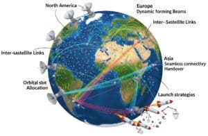
Satellite internet constellations deploy large numbers of low earth orbit satellites to provide global broadband connectivity with reduced latency. Inter-satellite links and phased array antennas enable dynamic beamforming and efficient spectrum reuse. Network topology and orbital slot allocation influence coverage and capacity, while handover mechanisms maintain seamless connectivity during satellite movement. Ground station networks interface with space segments, supporting data routing and constellation management. Launch strategies and debris mitigation debe address operational sustainability (not there yet).
Esta es nuestra última selección de publicaciones y patentes mundiales en inglés sobre Constelaciones de Internet por Satélite, entre muchas revistas científicas en línea, clasificadas y centradas en constelación de Internet por satélite, satélite de órbita terrestre baja, enlace entre satélites, antena phased array, formación de haces por satélite, despliegue de constelaciones, topología de redes de satélites, asignación de ranuras orbitales, reutilización de frecuencias, traspaso de satélites, red de estaciones terrestres, diseño de cargas útiles de satélites, arquitectura de segmentos espaciales, enlace cruzado de satélites, gestión de constelaciones, escalado de constelaciones de satélites, mitigación de desechos orbitales, comunicación por satélite, asignación dinámica de ancho de banda, gestión de potencia de satélites, sistemas de seguimiento de satélites, simulación de constelaciones, cobertura de constelaciones, redundancia de constelaciones, sincronización de constelaciones, encaminamiento de constelaciones, seguridad de constelaciones, mantenimiento de constelaciones, constelaciones de Internet y constelaciones de satélites.
Congestion management in satellite-based communications networks
Patent published on the 2026-10-15 in US under Ref US20260322724 by APPLE INC [US] (Talakoub Shahram [us], Seeber Sebastian B [us], Robson Travis J [us], Deo Saurabh [us], Adams Michael E [us], Moore Adam J [us], Williams Ashley M [us], Nelson Gregory R [us], Bhattarai Sudeep [us])
Abstract: [0000] A communications system may include a core network (CN) that communicates with a user equipment (UE) device via a satellite constellation. While a congestion level of a serving satellite in the constellation exceeds a threshold and an uplink message queue is empty, the UE may transmit heartbeat signals with a heartbeat period to signal to the CN that the UE device is still active in its communications session. Receipt of a reverse link signal such as the heartbeat may trigger the CN to re[...]
Our summary: This content discusses congestion management in satellite communications networks. It describes how user equipment transmits heartbeat signals to indicate activity during high congestion. The core network adjusts message priority based on the timing of these heartbeat signals.
congestion management, satellite communications, user equipment, core network
Patent
Communication method and apparatus
Patent published on the 2026-10-08 in WO under Ref WO2026208582 by HUAWEI TECH CO LTD [CN] (Zhang Jingwei [cn], Chen Ying [cn], Qiao Yunfei [cn], Zhang Jiayin [cn])
Abstract: A communication method and apparatus, which are applicable to the field of satellite communications, such as NTNs. The method comprises: receiving first configuration information, the first configuration information being used for indicating a first symbol to be muted and/or a second symbol not to be muted in a positioning reference signal resource; and receiving no positioning reference signal on the first symbol, and/or receiving a positioning reference signal on the second symbol. The technic[...]
Our summary: The communication method and apparatus improve satellite communications by managing positioning reference signals. It involves muting specific symbols to reduce interference. This enhances overall positioning accuracy in satellite systems.
satellite communications, positioning reference signals, interference reduction, configuration information
Patent
Satellite communication system, communication method, and program
Patent published on the 2026-10-08 in WO under Ref WO2026211858 by NEC CORP [JP] (Sugyo Kazushi [jp], Ariyoshi Masayuki [jp], Hasegawa Yohei [jp], Yoshida Kohei [jp], Araki Kota [jp])
Abstract: The present invention provides a satellite communication system, a communication method, and a program that improve the efficiency of communication resources for a redundant path. This satellite communication system comprises a path determination unit that determines a redundant path for a first communication path based on the arrangement of a plurality of satellites at a first time such that the redundant path at least partially overlaps a second communication path based on the arrangement of t[...]
Our summary: The invention enhances communication resource efficiency through a satellite communication system. It includes a path determination unit that identifies a redundant path overlapping with a second communication path. This is based on the arrangement of multiple satellites at different times.
satellite communication, path determination, communication efficiency, redundant path
Patent
Improved satellite beam switching
Patent published on the 2026-10-07 in EP under Ref EP4819507 by ST ENG IDIRECT INC DBA IDIRECT [US] (Nakhla Michel [us], Orgren Joseph [us])
Abstract: [0001] The invention provides, amongst other aspects, a method for automatic selective switching of a terminal from a current SA network to a target SA network in a satellite communication system, the method comprising identifying a need for switching the terminal from the current SA network to another SA network based on predefined switching trigger conditions, identifying at least one candidate target SA network from among a plurality of SA networks comprised in the satellite communication sys[...]
Our summary: The invention describes a method for automatic switching of a terminal between satellite networks. It involves identifying the need for switching based on predefined conditions and selecting a suitable target network. Measurement data, including network congestion and physical link conditions, is used to determine the best network option.
satellite communication, beam switching, network status, automatic switching
Patent
Rapid-switching rotatable waveguide polarizer feed assembly for maintaining satellite communications links during spot beam transition
Patent published on the 2026-10-06 in US under Ref US12756452 by MICRO ANT LLC [US] (Mccarrick Charles [us])
Abstract: A rotatable waveguide polarizer feed assembly for satellite and microwave antenna systems includes a stationary waveguide structure, a rotatable waveguide body, and an internal polarization-transforming structure positioned in an axial waveguide passage of the rotatable waveguide body. Internal transfer passages in the rotatable waveguide body selectively communicate with stationary waveguide channels. Rotation of the rotatable waveguide body changes the angular orientation of the polarization-t[...]
Our summary: The assembly enables rapid polarization state reversal for satellite communications. It features a rotatable waveguide body that adjusts the polarization-transforming structure. This technology maintains active links during transitions between spot beams of opposite circular polarization.
polarizer, waveguide, satellite communications, polarization reversal
Patent
Systems and methods for latency equalization in a satellite cellular telecommunications network
Patent published on the 2026-10-06 in US under Ref US12757141 by SPACE EXPLORATION TECH CORP [US] (Akella Ramakrishna [us], Chen Chen [us], Smith Darren E [us], Dunn Brian [us])
Abstract: [0000] A satellite computer system for a satellite can include at least one processor programmed to perform one or more steps. The satellite includes a phased array antenna configured to communicate with terrestrial user equipment (UE) via a plurality of directional beams. The steps can include: determining a signal latency for each of the beams based on a distance between the satellite and a reference location within the beam footprint during a time period; determining, for each of the beams, a[...]
Our summary: The system determines signal latency for satellite beams based on distance. It calculates beam buffer-delay times to achieve predetermined signal latency. Data streams are buffered in a variable delay Rx buffer according to these delays.
latency equalization, satellite telecommunications, phased array antenna, beam buffer-delay
Patent
A Multi-Modal and Sensor Fusion Dataset for Generative Modeling in Remote Sensing
Published on 2026-02-01 by Abdul Mutakabbir, Chung-Horng Lung, Marzia Zaman, Darshana Upadhyay, Kshirasagar Naik, Koreen Millard, Thambirajah Ravichandran, Richard Purcell @MDPI
Abstract: Earth Observation (EO) and Remote Sensing (RS) data are widely used in various fields, including weather, environment, and natural disaster modeling and prediction. EO and RS done through geostationary satellite constellations in fields such as these are limited to a smaller region, while sun synchronous satellite constellations have discontinuous spatial and temporal coverage. This limits the ability of EO and RS data for near-real-time weather, environment, and natural disaster applications. T[...]
Our summary: The NOAH dataset integrates Ground-Based Sensors with Remote Sensing data to enhance Earth Observation applications. It addresses limitations in spatial and temporal coverage for real-time disaster modeling. The dataset supports generative modeling techniques and is open-sourced for further research.
Multi-Modal, Sensor Fusion, Generative Modeling, Remote Sensing
Publication
Deployment and Performance in the South China Sea
Published on 2026-02-01 by Tongmu Liu, Baocheng Zhou, Xinwen Zhang, Jianqing Peng, Hua Huang, Tianhao Jian @MDPI
Abstract: Obtaining real-time data from the deep ocean remains a major challenge in marine observation. This study presents a deep-sea mooring system that integrates inductive telemetry (EUM6000 modules) with Tiantong satellite communication to achieve real-time, long-term hydrological monitoring in the South China Sea. The system incorporated 25 sensors, including CTDs and ADCPs, and was deployed at a depth of 1247 m. Over one year of continuous operation, it maintained a data reception rate >[...]
Our summary: This study presents a deep-sea mooring system that integrates inductive telemetry with satellite communication for real-time hydrological monitoring. The system achieved over one year of continuous operation with a data reception rate greater than 90% and a latency of less than 15 minutes. It provides high-resolution multi-sensor data that enhances understanding of ocean dynamics and supports climate research and disaster warning applications.
Telemetry, Deep-sea, Hydrological monitoring, South China Sea
Publication