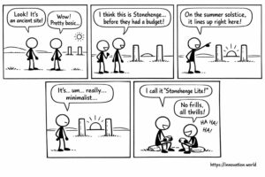
コミック:古代の投稿から、夏至の追跡に関する初期の記録が明らかに
今日のニュースを笑顔で見てみよう:研究者たちが、太陽の位置と一致する2本の柱からなる原始的な記念碑を発見した
今日のニュースを笑顔で見てみよう:研究者たちが、太陽の位置と一致する2本の柱からなる原始的な記念碑を発見した

This week: Powerline energy harvesting, UAV trajectory estimation, aerodynamic surface modulation, catenary curve analysis, UAV, flight termination, control network, electronic

This week: forest measurement, image recognition, machine learning, tree attributes, anomaly detection, machine learning, fluid injection, performance forecasting, Lidar, 3D

This week: health therapies, light arrays, hydrogen inhalation, oxygen bubbler, model compression, deep neural networks, batch normalization, loss function, motorized
This week: Powerline energy harvesting, UAV trajectory estimation, aerodynamic surface modulation, catenary curve analysis, Lidar, 3D object detection, autonomous vehicle,

This week: Lidar, 3D object detection, autonomous vehicle, point cloud data, LiDAR, aquatic environment, diode lasers, time-of-flight, robot path planning,